Author: Happy Pachani

  • World’s Highest Rail Bridge on Chenab River: 2026 Engineering Guide

    World’s Highest Rail Bridge on Chenab River: 2026 Engineering Guide

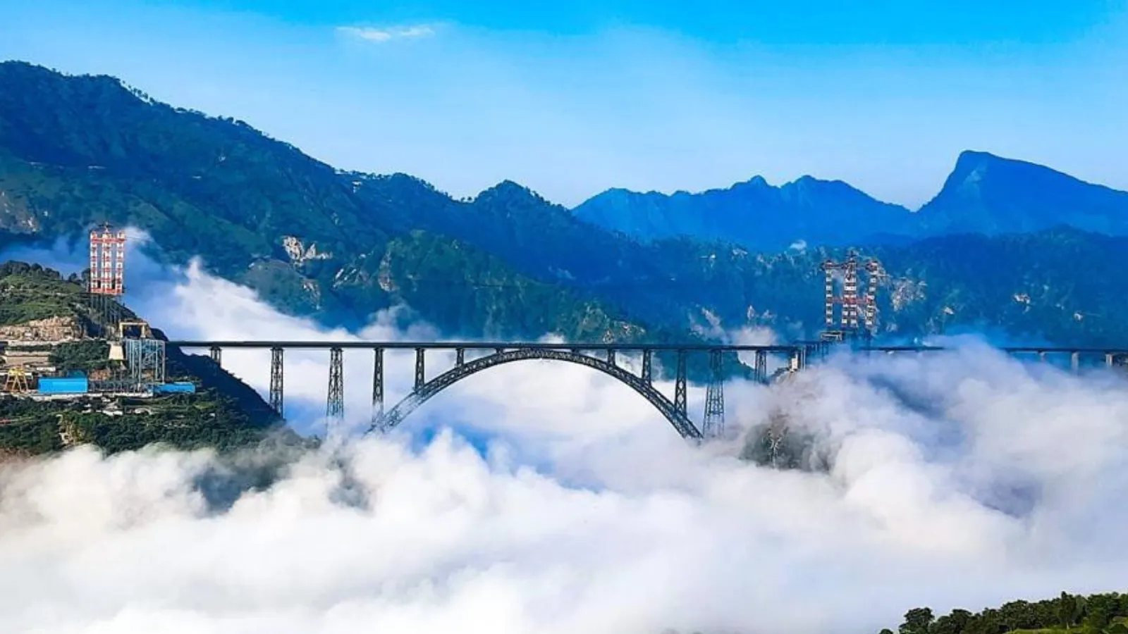
    Standing 359 meters above the riverbed in Jammu and Kashmir, the Chenab Bridge is recognized as the world’s highest rail bridge. Engineered as the critical link in the 272-kilometer Udhampur-Srinagar-Baramulla Rail Link (USBRL) project, this steel truss arch structure rises 35 meters higher than the Eiffel Tower to provide all-weather rail access into the Kashmir Valley.

    Key Takeaways (Quick Overview)

    • Elevation Record: Rises 359 meters (1,178 feet) above the Chenab riverbed between Bakkal and Kauri.
    • Structural Geometry: Features a 467-meter linear steel arch span within an overall bridge length of 1,315 meters.
    • Extreme Engineering: Calibrated for 266 km/h wind velocities and Seismic Zone V dynamic ground acceleration.
    • Career Pathway: Master structural modeling and finite element workflows through BIM professional training for civil engineers at Pinnacle IIT.

    Editorial Note: This guide reflects verified Indian Railways JUSBRL project specifications, Konkan Railway engineering data, and Indian Standard structural steel design codes (IS 800 and BS 5400). Technical parameters are audited directly from Konkan Railway Corporation Limited (KRCL) technical releases.

    Constructing a high-altitude railway corridor across the Pir Panjal mountains required structural civil engineers to address deep gorge topography, unstable Himalayan geological strata, and high aerodynamic forces. Here is the technical breakdown of the structural dimensions, design standards, and erection techniques that made the crossing operational.

    Engineering Specifications and Structural Dimensions

    The bridge structure consists of a large steel truss arch supported on concrete piers founded directly on stabilized dolomitic limestone rock. Below are the verified structural dimensions released by Konkan Railway Corporation Limited (KRCL):

    Project Parameter Design Specification Structural Context
    Structural System Two-ribbed steel truss arch Constructed from welded steel box sections
    Height Above Riverbed 359 meters (1,178 ft) Surpasses Millau Viaduct deck clearance
    Overall Bridge Length 1,315 meters (4,314 ft) Spans gorge between Bakkal and Kauri
    Main Arch Span 467 meters linear (550m curvilinear) One of the longest rail arch spans globally
    Structural Steel Quantity Approximately 28,660 metric tons Fabricated off-site in dedicated workshops
    Design Speed 100 km/h Broad-gauge passenger and freight traffic
    Designed Service Life 120 years Corrosion-resistant paint system applied

    Structural Steel Arch Design and Wind Resistance

    Due to the 359-meter drop, valley wind currents funnel through the Chenab gorge at severe speeds. The bridge deck and supporting arch were engineered to withstand sustained winds of up to 266 km/h (74 m/s). Designers conducted extensive boundary layer wind tunnel testing at Force Technology in Denmark to finalize the aerodynamic profile of the truss members.

    The main arch consists of two hollow steel box girders connected by horizontal and diagonal cross-bracing. Structural engineers utilized high-grade steel plates (E410 and E250 grades conforming to IS 2062) capable of maintaining ductility in sub-zero winter temperatures reaching -20°C.

    Blast-Proof Engineering and Seismic Zone V Analysis

    The bridge alignment sits squarely in Seismic Zone V, India’s most active earthquake classification zone. To protect the track and bridge piers, the structural design incorporates base isolation and energy dissipation bearings developed according to BS 5400 and Eurocode 8.

    In addition to seismic safety, the steel box girders are designed with blast-resistant internal baffles. Thick steel plates absorb dynamic explosive loads without compromising the global stability of the arch, ensuring the integrity of passenger rail operations through the Reasi mountain sector.

    BIM and Finite Element Analysis in Bridge Erection

    Erecting thousands of metric tons of structural steel suspended over a gorge required sophisticated computational design tools. Engineers used Building Information Modeling (BIM) platforms alongside finite element analysis (FEA) software (including Tekla Structures and MIDAS Civil) to simulate step-by-step cantilever cable crane erection.

    Two massive cable cranes, with a span of 915 meters, hoisted pre-assembled steel segments across the canyon. Real-time sensor networks tracked temperature expansion, cable tension, and wind deflections during each segment drop. Civil engineers seeking to manage major infrastructure projects can study these digital coordination workflows in the Pinnacle BIM Leaders program.

    Frequently Asked Questions

    What is the height of the Chenab Rail Bridge above the riverbed?

    The Chenab Rail Bridge stands 359 meters (1,178 feet) above the water level of the Chenab River. This makes it 35 meters taller than the Eiffel Tower in Paris and the highest railway bridge deck in the world.

    Where is the Chenab Rail Bridge located?

    The bridge is situated in the Reasi district of Jammu and Kashmir, India, connecting the villages of Bakkal and Kauri. It forms a key section of the 272-km Katra-Banihal segment of the USBRL rail corridor.

    What maximum wind speed can the Chenab Bridge withstand?

    The structure is engineered to withstand wind velocities of up to 266 km/h. An automated wind monitoring system halts rail traffic if gust velocities exceed 90 km/h on the open deck.

    What is the expected service lifespan of the Chenab Bridge?

    The bridge has an engineered design life of 120 years. Specialized anti-corrosive multi-coat polyurethane paint protects the steel superstructure against ambient Himalayan humidity and precipitation.

    How can civil engineers learn large-scale structural modeling tools?

    Civil and structural engineers can book a career counseling session with Pinnacle IIT to master software suites like Revit Structure, Tekla, STAAD.Pro, and Navisworks on live industrial project datasets.

    Read More On:-

    For more information about engineering, architecture, and the building & construction sector, go through the posts related to the same topic on the Pinnacle IIT Blogs page.

    Find out more accurately what we are going to take off in the course of applying leading new technologies and urban design at Pinnacle IIT.

    Subscribe to our YouTube channel and blog websites to obtain all the up-to-date information relating to construction matters.

    Advance Your Structural Engineering & BIM Career

    Train on real-world infrastructure and steel modeling workflows at India’s premier Autodesk Authorized Training Center with placement support.
    Download Syllabus & Check Batch Availability →

  • World’s Tallest Railway Bridge Pier (141m): Manipur Noney Bridge Engineering Marvel

    World’s Tallest Railway Bridge Pier (141m): Manipur Noney Bridge Engineering Marvel

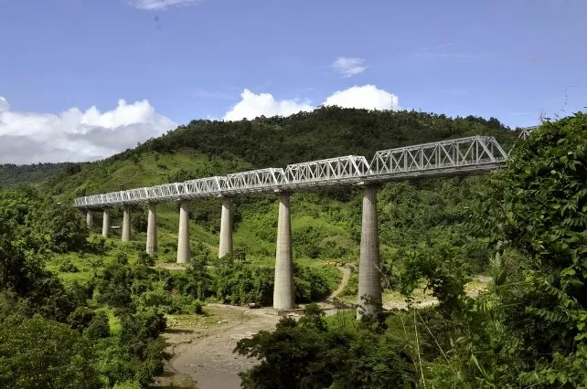
    The construction of the world’s tallest railway bridge pier across the Ijai River near Noney in Manipur stands as one of the most audacious civil engineering achievements in modern history. Executed by the Northeast Frontier Railway (NFR) and the Ministry of Railways, this 141-meter-tall hollow RCC pier surpasses Europe’s famed 139-meter Mala-Rijeka Viaduct in Montenegro, establishing a new global benchmark in bridge substructure design.

    Key Takeaways (Quick Overview)

    • Record Pier Height: 141 meters (462 feet) pier elevation, equivalent to a 45-story skyscraper.
    • Seismic Zone V Engineering: Hollow rectangular RCC cross-section reduces dynamic earthquake inertia forces.
    • Hydraulic Slip-Forming: Continuous 24/7 slip-form vertical casting at 2.5m to 3.0m per day.
    • Bridge BIM Modeling: Master complex infrastructure and bridge engineering in our BIM Course for Civil Engineers.

    Editorial Note: This technical case study is based on official project bulletins from Northeast Frontier Railway (NFR), RDSO bridge design guidelines, and Indian Railway Standards (IRS). Practical bridge modeling techniques are audited directly from Pinnacle IIT training curricula.

    Key Engineering Facts: Manipur Noney Railway Bridge

    Rising amidst the challenging Himalayan topography of Seismic Zone V, the Noney Bridge spans a total length of 703 meters. Pier No. P-4 reaches a staggering height of 141 meters from the river bed—equivalent to a 45-story commercial skyscraper.

    Structural Engineering Innovations in the 141m Pier

    1. Self-Climbing Hydraulic Slip-Forming: Due to extreme elevation and steep valley slopes, high-precision hydraulic climbing formwork was deployed, achieving continuous 24/7 vertical casting rates of 2.5 to 3.0 meters per day.
    2. Hollow Core Rectangular Pier Geometry: To minimize self-weight while maximizing second moment of area ($I$), the pier features internal cross-diaphragms and hollow chambers, significantly reducing dynamic seismic inertia.
    3. High-Performance Self-Compacting Concrete (M60 Grade): Specially formulated micro-silica blended SCC ensured flawless compaction around densely packed high-yield reinforcement without internal honeycombing.
    4. Deep Caisson and Raft Foundation: The pier is founded on massive cast-in-situ concrete rafts socketed deeply into sound bedrock to withstand severe earthquake tremors and mountain flash floods.

    World Record Comparison: Tallest Railway Bridge Piers

    Bridge Landmark Geographic Location Max Pier Height (m) Structural Type
    Noney Railway Bridge (Pier P-4) Manipur, India 141 meters Hollow RCC Pier / Steel Truss Deck
    Mala-Rijeka Viaduct Podgorica, Montenegro 139 meters Hollow Concrete Pier Viaduct
    Chenab River Bridge Jammu & Kashmir, India 359m (Deck Height) Steel Arch Railway Bridge
    Labohan Bridge Guizhou, China 138 meters Concrete Continuous Rigid Frame

    Frequently Asked Questions (FAQ)

    What is the height of the world’s tallest railway bridge pier in Manipur?

    The tallest pier (Pier No. P-4) of the Noney Bridge in Manipur stands at a record-breaking height of 141 meters (462 feet), surpassing the previous world record of 139 meters held by the Mala-Rijeka Viaduct in Montenegro.

    Which railway line features this iconic 141m bridge pier?

    The bridge is part of the 111-kilometer Jiribam-Imphal railway line project executed by the Northeast Frontier Railway (NFR) to connect Manipur’s capital city to India’s national broad-gauge railway network.

    Conclusion: Milestone in Infrastructure Engineering

    The 141-meter Noney Bridge pier exemplifies the pinnacle of Indian structural engineering. Engineers trained in 3D infrastructure modeling and parametric design play a critical role in executing such monumental projects.

    Build industry-leading infrastructure skills with our certified tracks: BIM Courses with Guaranteed Placement, BIM Course for Civil Engineers, and BIM Course for Architects.

    Read More On:-

    For more information about engineering, architecture, and the building & construction sector, go through the posts related to the same topic on the Pinnacle IIT Blogs page.

    Find out more accurately what we are going to take off in the course of applying leading new technologies and urban design at Pinnacle IIT.

    Subscribe to our YouTube channel and blog websites to obtain all the up-to-date information relating to construction matters.

  • Atal Setu: New Milestone in the Construction World

    Atal Setu: New Milestone in the Construction World

    Introduction

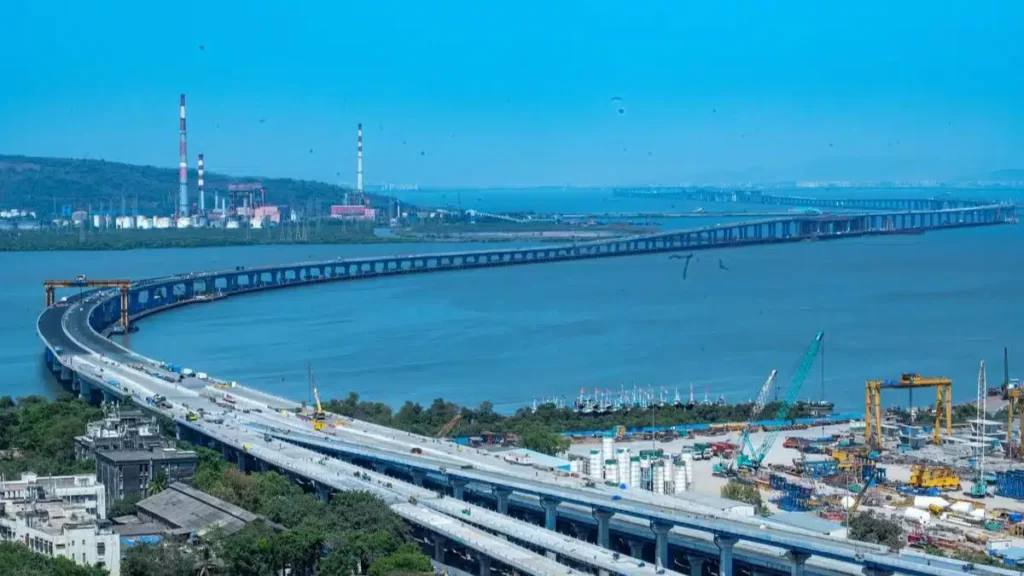
    The advent of a new age of connection in the vibrant landscape of Mumbai has been marked with the opening of Atal Setu. More than just a marvel of engineering, this bridge is a lifeline, seamlessly connecting South Mumbai to Navi Mumbai. The beginning of Atal Setu, named after former Prime Minister Atal Bihari Vajpayee, has turned what was once a two-hour trial into a quick 15 to 20 minute journey that conveys the essence of development and power of contemporary infrastructure.

    The Inaugural Leap

    When Prime Minister Narendra Modi unveiled the Mumbai Trans-harbour link, now the Atal Bihari Vajpayee Sewari-Nhava Sheva Atal Setu, it was a testament to India's infrastructural ambitions. Spanning 21.8 kilometers and costing over Rs 17,840 crore, the Atal Setu represents a significant milestone in infrastructure, a sector that has seen revolutionary changes thanks to Building Information Modeling (BIM) and its impact on architectural and construction practices.

    Design and Construction: A Testament to Perseverance

    The creation of Atal Setu was a challenge of grand proportions. Its construction over the Arabian Sea symbolizes India's capability to overcome geographical and engineering challenges, much like the role of BIM Managers in modern construction projects, ensuring precision and efficiency from conception to completion.

    Economic Growth and Connectivity of Atal Setu

    Atal Setu is a beacon of economic potential, promising to usher in a wave of development that will reshape the socio-economic fabric of the region. By facilitating smoother travel, it enables growth, much like how BIM is transforming urban planning and infrastructure.

    Image Credit: Business UpTurn

    Sustainable Development: A Core Objective of Atal Setu

    The bridge stands as a stepping stone towards sustainable infrastructure, reflecting India's dedication to green growth. This aligns with the growing trend of eco-friendly living and sustainable building practices that are crucial for the future.

    Bridging Aspirations of Atal Setu

    The Setu is more than a feat of engineering; it's a symbol of a nation's aspirations, reflecting the dream of a connected and prosperous future for all. It’s a clear indicator that, with the right BIM strategies, any construction project can turn into a landmark of national pride.

    Frequently Asked Questions

    Question: What role does BIM play in the construction of large-scale infrastructure like the Atal Setu?

    Answer: Building Information Modeling (BIM) is pivotal in modern construction projects. It enhances precision, boosts efficiency, and ensures that complex structures like the Atal Setu are built to last. For an in-depth understanding of BIM's benefits, explore how it is transforming the construction landscape.

    Question: How does the Atal Setu impact the economy and connectivity?

    Answer: By reducing travel time, the Setu fosters economic growth, enhances connectivity, and stimulates regional development. The bridge serves as a catalyst for new opportunities, much like how BIM streamlines MEP engineering.

    Question: Can infrastructure like the Atal Setu contribute to sustainable development?

    Answer: Yes, infrastructures such as the Setu is designed with sustainability in mind. The integration of BIM technology aids in creating eco-friendly designs and promotes sustainable development practices. Learn more about the impact of BIM on urban planning and sustainability.

    Question: What future developments can we expect in infrastructure technology?

    Answer: The future is bright with developments like BIM and sustainable materials, which are set to revolutionize infrastructure technology. Stay informed on the latest BIM tools and technologies that are shaping the industry.


    Conclusion

    The Atal Setu is not just an infrastructural project; it's a bridge to the future, embodying the harmony between aspiration and actualization, dreams and reality. As India strides forward, the Atal Setu stands as a testament to this progress, promising a future where distances cease to hinder growth and prosperity.

    For more insights into the world of engineering and construction, delve into the Pinnacle IIT Blogs, where innovation meets practicality.

    Discover more about how we're shaping the future of infrastructure and design at Pinnacle IIT.

  • Lakshadweep Islands: A New Tourists Place to Explore

    Lakshadweep Islands: A New Tourists Place to Explore

    Lakshadweep is a Union Territory of India, the smallest one but stunning coral islands consisting 36 small beautiful archipelagos, famous for its warm sands beaches enriched with vivacious corals and colored habitation. If you yearn for peace there is no better location and if you want adrenaline – this place fits any need, truly offering a unique combination of picturesque nature and action. Let’s go on an adventure in a virtual world of Lakshadweep; a place where peace and beauty lingers, history lives and thrives, living activities become outrageous.

    Image Credit : ADMINISTRATION OF LAKSHADWEEP

    Historical and Cultural Essence

    Lakshadweep hence has a history that is an intricate web made up of different civilizations like Cholas and Arabs but not only limited to these as the trade routes also increasingly brought other snippets into this basket. Culture is a fusion of Indian and Arabic values, which are reflected in the local celebrations like Eid and colorful dance forms such as lava natakam, paricha, and kudukali.

    Breathtaking Natural Beauty

    The Lakshadweep islands represent a picture-perfect epitome of clean beaches, turquoise waters, and lush greenery. Maritime diversity being evident, the coral reefs formed homes to various marine life making the islands a paradise for snorkeling and diving. Monadic islands of interest are Agatti noted for its beautiful lagoon and Bangaram Atoll boasting calm beaches with an upbeat coral life.

    Image Credit: Lakshadweep Tours and Travels

    Top Attractions and Activities

    Kavaratti Island

    • Beauty: Capital city, picturesque lagoon, white sandy beaches
    • Activities: Snorkeling, dolphin spotting
    • Special Mention: The Light House offers breathtaking panoramic views

    Agatti Island

    • Beauty: Turquoise waters and white sands, cultural hub.
    • Activities: Engage in local traditions, beach walks.

    Kadmat Island

    • Beauty: Coral kingdoms, exotic marine life, serene beaches.
    • Activities: Snorkeling, scuba diving, kayaking.

    Bangaram Island

    • Beauty: Bioluminescent beaches, teardrop-shaped island, secluded and romantic.
    • Activities: Nature exploration, experiencing bioluminescence.

    Kalpeni Island

    • Beauty: Largest lagoons, reshaped by a historical storm, ideal for water sports.
    • Activities: Reef walking, snorkeling, water sports.

    Thinnakara Island

    • Beauty: Secluded paradise, ideal for peaceful vacations and honeymooners.
    • Activities: Relaxation, water sports.

    Andrott Island

    • Beauty: Largest island, vibrant marine life, historical sites.
    • Activities: Visit Jumaat Mosque, explore ruins of Buddhist monasteries.

    Adventure and Leisure

    On the islands, there are a lot of activities for visitors to participate in; ranging from snorkeling to scuba diving and kayaking as well as island hopping using traditional “oti” boats. The quiet waters and abundance of marine life makes this region an perfect dive site especially when you go into the sea.

    Gastronomy

    Taste local delights mostly coconut-enriched traditional recipes and fresh sea products that bring back the flavor of tropical islands.

    Accommodation Options

    Agatti Island: Traditional villages and rooms equipped with only the essentials and marvelous beach sightings.
    Bangaram: Luxury tent and cottage as an accommodation.
    Travel Essentials
    Best Time to Visit: Between October to March when the weather is nice and sea calm.
    Connectivity: Intermittency can happen in internet and mobile networks.
    Restrictions for alcohol might be there, therefore one must consult the agent before undertaking a trip.

    Planning Your Visit

    How to Reach: Accessible via from Kochi, Kerala. Lakshadweep Tourism-issued permits are necessary too.
    Accommodation: From lavish resorts to wallet-friendly guesthouses.
    Activities: Swimming, island touring, and shopping for handicrafts in the local markets.

    Cost Overview (Approximations)

    Please note that prices can vary based on the season and availability. It's advisable to check the latest rates and confirm bookings in advance.

    Suggested Itinerary

    Day 1: Arrival at Agatti, Transfer to Bangaram Island

    • Arrive at Agatti and transfer to the picturesque Bangaram Island.

    Day 2: Beach Walk, Ayurvedic Massage, Local Food Exploration

    • Enjoy a leisurely beach walk on the pristine shores of Bangaram.
    • Pamper yourself with an Ayurvedic massage for relaxation.
    • Explore local cuisine, savoring the unique flavors of the region.

    Day 3: Hike, Shell Picking, Transfer to Minicoy Island

    • Embark on a scenic hike on Bangaram Island.
    • Engage in shell picking, a serene activity on the island.
    • Transfer to Minicoy Island for the next part of your adventure.

    Day 4: Explore Minicoy, Adventure Sports, Transfer to Kalpeni Islands

    • Discover the beauty of Minicoy Island and its cultural highlights.
    • Engage in thrilling adventure sports for an adrenaline rush.
    • Transfer to the enchanting Kalpeni Islands for the next leg of your journey.

    Day 5: Walking Tour of Kalpeni, Local Cuisine Tasting, Departure

    • Immerse yourself in a walking tour of Kalpeni, exploring its charm.
    • Indulge in a tasting of local cuisine, experiencing the island's flavors.
    • Depart with cherished memories of the Lakshadweep Islands.

    Conclusion

    In summary, Lakshadweep is an ideal paradise that enchants with its natural beauty, rich history and vivacious inhabitants. These islands are a perfect destination for seekers of adventure, people who love beaches and also culture lovers whereby they will find an exciting and lasting experience. 

    Its pristine beauty, coupled with its uniqueness in terms of culture and the environment makes it a must-visit spot to see nature at large undiluted which is rare for people who experience too much city life.

    For further in-depth insights on current affairs, consider exploring the enlightening blogs at Pinnacle IIT Blogs.

  • Empower Your Career: Uncommon Skills of an MEP Coordinator

    Empower Your Career: Uncommon Skills of an MEP Coordinator

    The role of an MEP (Mechanical, Electrical, and Plumbing) Coordinator is pivotal in the construction industry. This multifaceted profession requires a unique set of skills that go beyond the traditional engineering capabilities. Let's delve into the uncommon talents that can empower your career as an MEP Coordinator and set you apart in this competitive field.

    The Unique Skill Set of an MEP Coordinator

    Technical Coordination Expertise

    At the core of MEP coordination is the expertise in handling complex technical aspects of mechanical, electrical, and plumbing systems. This involves a deep understanding of technical coordination expertise, ensuring all systems are integrated seamlessly within a project. For insights into this complex role, explore the world of MEP Engineers.

    Communication Mastery

    Effective communication is key in the role of an MEP Coordinator. It involves articulating complex technical details to different stakeholders, from architects to on-site workers. This communication mastery is essential for ensuring that all parties are aligned with the project's objectives. Enhance your communication skills in MEP by checking out MEP's necessity in plumbing.

    Image: Showcasing diverse professionals mastering the spectrum of communication

    Project Management Prowess

    An MEP Coordinator must possess project management prowess, overseeing the project from conception to completion. This includes scheduling, budgeting, and ensuring compliance with safety regulations. Understanding project management in MEP is crucial for a successful career. Learn more about project management skills in BIM for MEP designers.

    Problem-Solving Abilities of an MEP Coordinator

    The ability to quickly and efficiently solve problems is a hallmark of an effective MEP Coordinator. This involves being able to identify potential issues and create solutions that keep the project on track. Develop your problem-solving abilities by exploring BIM's role in construction.

    Image: A glimpse into a workspace where diverse minds unite to tackle complex problems

    Software Proficiency

    In today's digital age, software proficiency, especially in BIM (Building Information Modeling), is non-negotiable. MEP Coordinators need to be adept at using industry-standard software for design, analysis, and project management. Discover the importance of software skills in MEP through BIM's advantages in architecture.

    MEP Coordinator: A dynamic portrayal of diverse professionals excelling in various software applications

    Image: A dynamic portrayal of diverse professionals excelling in various software applications

    Collaboration and Leadership of an MEP Coordinator

    Lastly, collaborative leadership plays a vital role. An MEP Coordinator must lead teams, collaborate with various departments, and ensure that all members work towards a common goal. This skill is pivotal in empowering your career in MEP coordination.

    Frequently Asked Questions

    Question: What distinguishes an MEP Coordinator in the industry?
    Answer: An MEP Coordinator stands out through uncommon MEP talents such as advanced technical knowledge, excellent communication, adept project management, and strong leadership skills.

    Question: How does BIM integration enhance an MEP Coordinator's role?
    Answer: BIM integration is crucial for MEP Coordinators as it allows for more efficient planning, execution, and maintenance of building systems, leading to improved project outcomes.

    Question: Can an MEP Coordinator have a significant impact on project success?
    Answer: Absolutely. With their technical coordination expertise and project management prowess, They plays a critical role in steering projects towards success.

    Question: Are soft skills important for an MEP Coordinator?
    Answer: Yes, soft skills like communication proficiency and collaborative leadership are essential for effective teamwork and project success in MEP coordination.

    Question: How can one develop the uncommon skills necessary for an MEP Coordinator?
    Answer: Continuous learning and practical experience, along with staying updated with the latest industry trends like BIM technology and sustainable practices, are key to developing these skills.

    Conclusion

    An MEP Coordinator's role is both challenging and rewarding, requiring a blend of technical, managerial, and interpersonal skills. By mastering these uncommon talents, you can significantly empower your career and become a valuable asset in the MEP sector.

    For further insights and career guidance in MEP, visit Pinnacle IIT and explore a wealth of resources tailored for aspiring MEP professionals.


    Discover more about career empowerment and MEP coordination skills in the following resources:

    Remember, the journey to becoming an effective Coordinator is continuous and ever-evolving. Stay curious, keep learning, and keep pushing the boundaries of your professional capabilities.

  • Architect or BIM Manager: Which is the Best Career?

    Architect or BIM Manager: Which is the Best Career?

    In the ever-evolving realm of construction and design, the roles of Architect and BIM (Building Information Modeling) Manager emerge as significant career choices. Each of these professions, whether as an Architect or BIM Manager, holds a critical role in the fabric of building and design. Their contributions, while pivotal to the construction process, vary greatly in terms of responsibilities, required skills, and potential career trajectories. In the forthcoming sections, we will delve into these variances through both a tabulated comparison and an in-depth analysis.

    Comparative Table: Architect or BIM Manager

    Detailed Discussion

    Architects: The Visionaries of Building Design

    Architects are the creative force behind the physical appearance and functionality of buildings. Their work balances aesthetic appeal with practicality, adhering to creative architecture paths and building codes. Architects are involved from the conceptual stage to the completion of a project, making critical decisions that affect the building's look and feel. For those intrigued by design and artistic expression in architecture, following the career growth in architecture can be immensely fulfilling. Discover more about the creative aspects of architecture in Pinnacle IIT's exploration of emerging trends.

    Image: Architects in their element, blending creativity and innovation

    BIM Managers: The Technological Backbone

    BIM Managers represent the integration of technology in construction. They manage digital representations of physical and functional characteristics of places, ensuring that building projects are efficient and error-free. This role is pivotal in building design vs. digital models, focusing on the accuracy and optimization of construction workflows. BIM Managers require a blend of technical skills and an understanding of construction processes, making it a suitable career for those interested in the technological side of building design. For insights into the role of technology in construction, read about BIM in Civil Engineering.

    Image: A BIM Manager central to the synergy of technology and architecture

    Choosing Your Path

    The decision between becoming an Architect or BIM Manager depends on your interests and skill set. If you are drawn to creative architecture, the role of an Architect may be more satisfying. However, if you are fascinated by the technology in construction and have a knack for managing complex digital systems, a career as a BIM Manager could be more appealing.

    Explore more about these roles and make an informed decision about your career by visiting Pinnacle IIT, where you can find a wealth of resources and guidance on both these exciting career paths.

    In conclusion, whether you choose to pursue a career as an Architect or BIM Manager, each path offers unique challenges and rewards, shaping the future of the built environment in distinct yet complementary ways.